Showing posts with label 1991. Show all posts

Thursday, August 15, 2024

Remembering Beaumaris

Beaumaris Castle, 1991.

It hasn't changed much.

Even before I went onto Google Maps street view in The Conqueror app, I knew what the road would look like. Though it was a major thoroughfare, I imagined that they hadn't widened Beaumaris Road, that it was still a two-lane roadway with stone walls on either side.

I finished my spin bike ride and entered the results into my Garmin watch app, which automatically sent the relevant data to the virtual travel app. Though I wanted to reach the town of Beaumaris by the end of my day, the stationary bike ride didn't do it.

I'd have to rely on my daily steps to get me the rest of the way.

But I did look at where I was on the route before adding up my steps, and Beaumaris Road hadn't changed a bit. I was still about five kilometres away from my ultimate destination, and I had completed more than four through the day, already.

The last time that I was in Wales, in real life, was in 1991, with DW. We had started in London, made our way to Stratford-upon-Avon, and entered Wales between Shrewsbury and Chester, making our first stop at Valle Crucis Abbey before continuing on to Conwy, in the north.

So far, during my virtual trek, I've revisited a couple of places from our real adventure: Conwy and Bangor. Crossing over to the Isle of Anglesey, I was approaching my next destination, Beaumaris.

As I readied for bed, I saw that I was just a couple of hundred metres away from the app's milestone marker, so I marched on the spot to cover that distance. Once I reached that marker, I entered my steps and got ready to see the town.

However, the milestone only put me at the western outskirts of the town, and I had nearly another kilometre before I would reach the actual town and the spot where I really wanted to be: outside the castle.

DW and I had originally made our way to Beaumaris Castle late one afternoon, only to discover that we were too late to get in, and that the gates had closed a short time earlier. We made our way to Bangor, where there was a campground for us to spend the night.

We ended up returning to the castle the next morning.

It took me a couple of attempts on the app to make it to the castle, which is on the eastern end of the town, before the roadway bends northward. I walked around the room, watching my watch count up distances, entered them into the app, and then checked the map. And repeated four times.

Finally, I reached the familiar spot.


There's now a large car park to the northeast of the castle, where I had once only seen sheep in a field. The rest of the town hadn't seemed to change, otherwise.

Sheep surrounding the castle remains, 1991.

The Conqueror Virtual Challenge now has me following the eastern shores of the Isle of Anglesey, circumnavigating the coastline in a counter-clockwise direction before I cross back onto the mainland and continue west, toward Caernarfon, another spot that brings back fond memories.

Happy Thursday!

Thursday, November 23, 2023

Memories Fade But the Photos Linger

I don't remember the place, though the country was Wales. We were possibly near Cardiff but I can't remember with certainty.

It's been more than 32 years, after all.

DW and I were travelling the countryside and we had heard about a medieval festival, with mock battles, plenty of costumes, and simple food. But sadly, that's all I remember from this short stop.

At one point, we went into a stable and were able to try on certain costumes from that time. I know that this photo was taken in that stable because in the original, underexposed photo, there's a life-sized model horse behind me.

And I placed a helmet on my head.


DW had taken the shot but there hadn't been enough light and the colour in the processing made my face a bright red. I needed to use both of my photo-editing software tools, after scanning the negative, to get this photo to look as good as it is (and I know, it's not very good).

While my memory of this day has faded, my memories of travelling Wales have not. It's a trip I'll never forget and I hope to one day return to this beautiful country.

Happy Thursday!

Wednesday, April 21, 2021

Brain Food

My brain was full.

In seven days, DW and I had driven from London, England, to Stratford-upon-Avon, through the north of Wales, across Snowdonia, along the western shores, and to the southeast before crossing back into England, where we visited historical Bath and Stonehenge. We were now in Salisbury and we had to have our car back at the rental agency, in London, by mid-afternoon.

There were so many places still to discover on this magnificent island and we knew that someday, we'd have to return (excluding Heathrow Airport, it's coming up on 30 years since we've made that promise and have yet to see England or Wales again). We wanted to see one more historic place, and when we checked the maps to see what was within range and our window of time, and we decided to head to the birthplace of England's institute for higher education.

We drove to Oxford.

Now, I'm sorry to say that I had run out of film after stopping at Stonehenge. At least, I thought I had run out. In truth, I did have one unexposed roll of 35mm film, but at that point I hadn't realized that I had shot one roll twice. But I had allocated so many rolls of film for each day and hadn't counted on taking any photos on the day that we were heading back to London.

Our friend, Catheleen, was holding onto my extra rolls of film that were allocated for our next leg of our vacation—more on that to come. And sure, I could have stopped somewhere to buy another roll, but I was young, not the experienced photographer that I am today, and I was on a limited budget (and cheap).

All of that to say that my images of Oxford, for this post, are taken from Google Maps.

Photos via Google Maps.
Time really wasn't working in our favour. I made a couple of wrong turns on the roadways, and what should have taken no more than an hour and forty-five minutes took us more than two hours. By the time we reached Oxford's High Street, it was nearing lunchtime, and DW and I could only think of food (we were growing tired of Weetabix breakfasts). The roads in town were busy and my luck of finding a good parking space had run out. We settled for driving around the city, taking in what our eyes would allow us, and then find a place to stop for lunch as we were heading out of Oxford.

Photos via Google Maps.
The buildings in the heart of Oxford and at the university are larger than life and draw the eye to the gorgeous architecture. In a way, it was fortunate that traffic was busy: it allowed me to take my attention, briefly, away from the road. I remember driving past University Church of St. Mary the Virgin (that poor woman, being labelled a virgin her whole life!), Carfax Tower, and Tom Tower.

Tom Tower, photo via Google Maps.
There was so much more that we saw from the roads, but this visit was so short that it now remains as a fog in the cobwebs in my brain. Scanning the city with Google Maps street view, I could see a building and think, yeah, that's vaguely familiar, or yeah, I saw that.

But time was running out and our stomachs were grumbling, so as I negotiated our way out of Oxford, DW searched our guidebook for a place to eat.

"We haven't had fish and chips in England," DW said. "We can't leave England without fish and chips, served in newspaper."

"I've worked for newspapers," I reminded her. "Fish that's been blackened by ink doesn't appeal to me."

Nevertheless, she found a highly rated fish-and-chips takeaway, which was on the road we needed to take to get to the M40 motorway. I remember the proprietor, a plump man with thinning black hair and a perpetual five-o'clock shadow, with a stained white t-shirt and an apron that hung from his ample waist. He was interested in our Canadian-ness and wished us well as he wrapped our fish and sent us on our way.

I ate while I drove, and the grease from the fry began to soak through the newspaper and burn my hands. The fish was super-hot, the batter crisp and crumbling. DW and I shared a serving of fat, crisp chips (French fries, of course!), and I remember having to quickly pass her my fish as I shifted gears and negotiated traffic circles.

There was nothing left but to make our way to London, and we returned our Ford Fiesta within minutes of our deadline. I pointed out the scratches, explaining that it happened in Caernarfon, while we were parked at the castle, to which the attendant only grunted, as if to say he expected no less. Because our insurance covered for all damage, we didn't have to worry about it.

We lugged our gear across the city, this time without help from our friends, and we crashed for the evening in the SoHo youth hostel.

Our trip around the UK was at an end, but our vacation was only just half-over. The next day, our friends, Catheleen and Joel, would be joining us on our next leg, Paris.

Like our UK trip, this Paris leg has a few blurred memories and I'm not sure that I want to tell it just yet. So I'll end this travel adventure here, and perhaps I'll share the Paris trip closer to its 30-year anniversary mark, in May.

Until then, if you're interested in seeing Paris, you can always see the family trip that DW and I took, in 2014, with our kids. That year, we saw a lot of France.

Tuesday, April 20, 2021

Taking a Bath

Our trip was coming to an end and it seemed like such a whirlwind that it was hard to take in all that we saw. Maybe that's why, today, DW and I still can't remember the trip in clear detail.

We were in the city of Bath, in England, for such a short time that I think of it as just a dip. As in, we just dipped our toes into Bath. Get it? (Of course you get it.)

Our destination was the Roman baths.


One of the things that I remember most about driving through the various towns and cities in Wales and England was that we never seemed to have any difficulty parking, no matter where we went. I mean, we did have someone key our rented Ford Fiesta, but we never had a problem finding a place to park the car. I'm generally a cheapskate when it comes to paying for parking, especially when I was young and didn't have much money in the first place, and I also had great luck in finding a free parking spot when there was very little available.

I remember that we parked our Fiesta on a side street, not far from Bath Abbey and the Roman Baths, but on the opposite side from the River Avon. We walked the few blocks to reach our destination, crossing over the Pulteney Bridge, a bridge that is lined with various shops, much like the Ponte Vecchio, in Florence, Italy, and dates back to 1774.

The day was beautiful, with lots of sunshine and warm temperatures. Around the Abbey Churchyard and in Kingston Parade, the plaza between the church and the baths, buskers of all types were entertaining the visitors. DW and I didn't stop, didn't waver from our quest. We had a lot of travelling to do on this final full day with our rental, and we didn't have time to waste. Perhaps, after our tour of the Roman Baths, when we planned to stop for a bite, we would watch the entertainment.

Romans built a temple on this site between 60 and 70 on the Common Era calendar. They named this settled area Aquae Sulis and the actual thermal spring was made into what was known as a thermae, a large imperial bathing complex. The baths were used until the fifth century, when the Romans left Britain, and 100 years later, the whole complex lay in ruins.

The area was redeveloped several times over the following centuries and eventually the spring, bath temple, and a museum were preserved. Today, it is one of England's biggest attractions.

It really is quite impressive, especially when you stand on one corner of the bath and gaze up toward the street level and the imposing abbey spire. It's as though you're looking at two separate time periods at the same time.

The bath lies in an open-air area below street level and looks like a modern-day swimming pool, though bathers are not permitted in it. I remember the humidity as we were led by a tour guide around the pillars that support the upper deck. We finished the tour, snapping some photos along the way, explored the museum, and then headed out for lunch.


Before leaving the city and heading to our next destination, there was one other famous landmark in Bath that we wanted to see. We hopped in our Fiesta and headed to the northern end of the city centre, and drove around The Circus, a large road circle that has a treed island and is enclosed by massive, curved Georgian townhouses. Built between 1754 and 1768, the name is Latin for circle


There were no elephants or big tent, and I was the only clown there.

We swung onto one of the three spokes of The Circus and stopped at No. 1 Royal Crescent, a sort of half-circus, of 30 uniform, Palladian apartments that form a massive crescent.


A couple of quick snaps and we were on to our next destination, which I have touched on briefly when I was setting up for this series of travel blog posts.

The journey concludes tomorrow. Or does it?

Stay tuned.

Monday, April 19, 2021

Borders

For the final full day in Wales, in 1991, we were finally on schedule, weren't rushed to get to our destination.

From Cardiff, we made it to Chepstow, in the southeast corner of Wales and right on the border with England, and we were able to pitch our tent before we lost light. But the full day in the city that has a family connection, mixed with the earlier drive, from Caerphilly, wore us out and had us call it an early evening. We wouldn't explore the city until the next morning.

We awoke the next morning energized and ready to tackle the day. Time with our rental car was coming to an end and we needed to be in London before the rental agency closed, the following day. And before then, we still had a lot of ground to cover and two more Welsh sites to see.


When we were planning our trip and learned that there was a castle in Chepstow, high on a clifftop over the River Wye, we knew we had to pay it a visit, especially since it was so close to our last planned stop before crossing the border, back into England.

Chepstow is the site of the oldest post-Roman stone fortification in the UK. Built by a Norman lord, in 1067, it saw lots of action during the Welsh rebellions and finally fell into disrepair after the English Civil War of the 1600s.

Too bad the Marquees of Bute didn't take it over.

Here's some trivia: in 1977, Monty Python member, Terry Gilliam, shot parts of his film, Jabberwocky, at Chepstow Castle.

While DW and I stood high above, in the Great Hall, we looked down onto the River Wye and saw boats pulling water-skiers (see the fifth photo, below). Talk about your past and present.


After exploring the castle, we wandered down to the bridge that we could see from the heights of the castle, which borders on the Welsh-English border. We were going to cross that border soon enough, but for now we were going to drive further north along the Welsh side of the Wye, to a famous abbey.

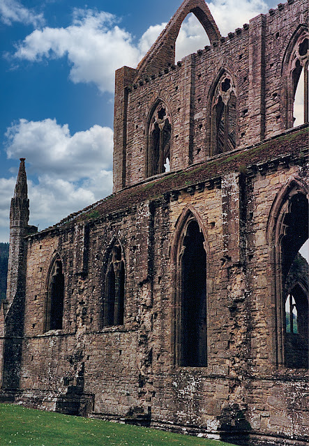
Driving along the A466 and down the hill that leads in to the valley in which Tintern Abbey is situated, we could understand the awe that poet William Wordsworth, and other poets and artists, had felt when they beheld this massive structure. It appears large at first sight and gets even bigger as you get closer and closer.


In its heyday, it must have been remarkable to see.

Founded in 1131 by the Cistercians, there is evidence that places of worship go back centuries earlier. The abbey's end came in 1536, after King Henry VIII dissolved the monasteries in England. The lord of Chepstow took possession and sold off the lead roof, and the building fell into decay.

There were plenty of visitors when DW and I arrived but the church and its grounds are so large, and covers such a vast area, that we often felt as though we were the only ones there.


Our trek through Wales was at an end. We had begun our journey at an abbey in ruins and ended it at another abbey, also left as a shell of its former self. In between, we had seen some awe-inspiring castles, steeped in history, and we had driven over some of the most beautiful landscape that I have ever seen.

Because I was our driver—DW doesn't drive manual-transmission vehicles and didn't feel comfortable driving on the left, so I was the only one insured to drive the Fiesta—I was constantly looking to the right and left as we meandered the peaks and valleys of the terrain, and at times I had to pull over and get out of the car to take in the majesty of it all. I remember, at one point, I was so overcome by the beauty that tears rolled down my cheeks.

Wales is breathtakingly beautiful.

From Tintern Abbey, we backtracked to Chepstow and then crossed over to England, where we made a B-line to Bath.

More to come.

Thursday, April 15, 2021

Family

My mother told me that I had met my aunt when I was too young to remember. It was in Montreal, when I was a baby.

The Brown family comprised 14 kids: my dad, lucky number 13, had siblings who were old enough to be his parents, as the age gap was considerable. And when my grandfather, Sidney Brown, died, my dad was only two years old and many of his eldest brothers and sisters helped to raise him and his infant brother, my Uncle Don.

'Nanny' Brown, 1950s.
My grandmother (who I called "Nanny"), Vena Penk, was Welsh. I don't know if she ever returned to her home country after marrying my grandfather and moving to Canada, though I do know she lived for a time in Haiti and in California. The last time I saw her, I was about 10.

But one of my older aunts, Miriam, moved to Cardiff, Wales, after she married, and she was still living there when DW and I were travelling the Welsh countryside in spring, 1991.

When I told my mother that DW and I wanted to reach out to Aunt Miriam when we reached Cardiff, my mom gave me my aunt's phone number. My plan was to call her when we were in Conwy, to give her a couple of days' notice that DW and I were in the country, and that we would like to drop in for tea, if she was available.

Unfortunately, either I forgot to take the number with me when we left Canada or I lost the number from my backpack while I was unpacking and repacking it over the previous days. I was going to give up, but when we finally reached Cardiff, on the Bristol Channel in the south of Wales, I called my mother to get Aunt Miriam's number again.

DW and I planned to tour the castle, have lunch, and then visit my aunt in the afternoon.

"She's not home," my mother said when I called her.

"How do you know?"

"Because she's here, in Ottawa. I saw her yesterday." My aunt was in Canada, visiting her brothers and sisters who were living in Ottawa and in Montreal.

What were the chances?

At least we still had the castle to see.


In 50 CE, the Romans established a settlement in Cardiff, and after the Norman conquest, a motte-and-bailey castle was built upon the Roman ruins. Over the centuries, wood was replaced with stone and the grounds around the castle were further fortified. It wasn't until the 18th century that the castle and its lands were handed to the various Marquess of Bute (who also owned Caerphilly), whose heirs cared for the existing structures and added modern ones to the grounds. Today, the Welsh historic society cares for the castle, which is a grand palace that is built around a Norman keep, which is built on a Roman settlement.

In other words, this site is teeming with history.


As with other Welsh tour-guide photos, I was drawn to one of a peacock, which roams the grounds, as he was posed, tail-feathers spread, with the Norman keep in the background. I knew that the chances of getting the bird with its fan-like tail open was a long shot, if I could even get a photo of the bird with the old castle in the background.

What were the chances?


Our tour of Cardiff Castle completed, we also decided to visit the Welsh Folk Museum, St. Fagans, before heading out of the city. Though we didn't reunite with my Aunt Miriam, visiting her home city made me feel just that much closer to the Penk side of my family. I would eventually meet her, in 1999, after DW and I returned home from our two years of living in South Korea, at a Brown family reunion in Nepean. And Aunt Miriam bore a striking resemblance to Nanny Brown.

We eventually made our way eastward, back toward England. But we still had one more castle and a famous abbey to see before we explored the south of England and made our way back to London.

Stay tuned.

Wednesday, April 14, 2021

Cracked Up

For a photographer, there's nothing worse than travelling great distances to a photogenic site—a place where you won't be returning to any time soon—only to find the site covered in scaffolding, with fabric blocking the view even further, no matter how slight the covering is.

Such is what met us at Caerphilly Castle, in southern Wales.


We drove for most of the morning, from Devil's Bridge, reaching Caerphilly before lunch. Originally a fortified Roman settlement that dates back as far as 75 CE, the town is now quite sizeable. At its centre, a castle dates back to 1268 (it was completed in 1290). Caerphilly Castle is the largest castle in Wales and the second-largest in the UK, after Windsor Castle.

While the castle saw major attacks throughout its life, the bombardment by Oliver Cromwell, during the 1642 English Civil War, resulted in the southeast tower splitting open and leaning at an angle that is greater than that of the Tower of Pisa, in Italy, but never fell. In the century that followed, parts of the castle had collapsed and the castle looked like it was headed for total ruin, but in the late 1700s, John Stuart, the Marquess of Bute, took steps to restore the castle. Over the centuries, his heirs made efforts to reroof the great hall and buy back the land around the castle, which by this time had town homes and structures built right up against it.

In 1950, the final marquess gifted the castle and surrounding grounds to the Welsh state, and Caerphilly Castle has been held under its care ever since.


Despite the scaffolding and coverings (okay, there wasn't much that was covered, but still...), it was nice to know that this historic site was being well cared for.

DW and I explored every nook and cranny of this castle, including the biggest cranny of them all.


Our next stop was to visit family, in Cardiff.

Stay tuned.

Tuesday, April 13, 2021

The Devil Made Me Do It

We had no tent to take down, no equipment to pack up. Our breakfast was Weetabix, served in stainless-steel mugs that we could easily rinse out at the comfort station. We were on the road before the other campers came awake, before the grounds opened up.

We didn't realize that Devil's Bridge was a site that required an admission fee. And when we pulled up to the vacant parking lot, we could see that the village of Pontarfynach and neighbouring inn were still a-slumber.

But we couldn't wait.

The staircase that led under the bridge was blocked by a turnstile. We had to contort our bodies to squeeze through the gaps between the bars (there's just no way I could do that today!) and DW helped me get my camera bag over the gate. The pathway down was surrounded by dense scrubs and trees, and the sound of the tumbling water—echoing in the chasm and at the base—was deafening. No one would hear us over the splash of the falls.

Devil's Bridge is a stacking of three bridges: the lowest and first-built is suspected to have been built by the Strata Florida Abbey monks, who were looking to ease access to their nearby abbey. It dates from between 1075 to 1200. When it became unstable, a second bridge was built atop it in 1753: the original bridge was used in the second bridge's construction, to hold scaffolding. In 1901, an iron bridge was built above the second bridge.


Local folklore claims that the first bridge was built by the Devil, who offered to help an old woman retrieve her cow, which had somehow crossed to the other side of the Afon Mynach (Monk River, in English). In exchange for his help, the woman promised to give the Devil the first living thing that crossed the bridge.

The woman sent her dog, thereby tricking the Devil.

At the bridge, the river falls 91 metres over five tiers, landing at what is known as the Devil's Punchbowl. We took a few photos but the rain threatened to soak us, so we only spent a few minutes, hoping to get out before anyone caught our trespass.


At the ticket booth, we left a handful of coins. Not enough to cover the admission cost but enough, in our minds, to cover the brief stay and our partial walk (we didn't hike the whole trail or visit any of the other lookouts).

Back in our Ford Fiesta, we made our way to our next destination. Stay tuned.

Monday, April 12, 2021

Harlech

"How much is an overseas stamp for a postcard?" I asked the postmaster.

"To America?"

"To Canada."

"Oh, I'm so sorry." It seemed, to the postmaster, that calling a Canadian an American was as offensive as calling a Welshman an Englishman. I took no offence as I applied the stamps and placed them in the mailbox.

Outside, the day was as dark as evening and the rain came in spurts as the winds blew heavily off Bae Ceredigion and, further out, the Irish Sea. We left the Harlech Post Office and walked the short distance to the castle. Both the town and the imposing castle—another of Edward I's examples of English might over his Welsh subjects—lie on a hill above the bay and bear the full force of any eastward gales. We zipped up our rain shells and prepared for a late afternoon of exploring.

Just outside the southern walls of the castle stands a statue of two figures on a horse: one of the figures lies across the horse; the other, whose head hangs in sorrow. Two plaques—one in Welsh; the other, English—explain a Celtic mythological tale. The English plaque reads as follows:

The Mabinogion story of Branwen is a lament over the folly and carnage of war. Branwen, sister of Bendigeidfran, the King of Britain, departed from the court at Harlech to marry the King of Ireland. Their son, the boy King Gwern, was killed in the war which followed.

In the sculpture, the figure of Bendigeidfran, bearing the body of his nephew Gwern, symbolises the sorrowful burden that love can be.

We had the castle to ourselves. On his cold, damp, and blustery day, who else would venture out? Harlech, built between 1282 and 1289, was our fourth castle in ruins, and we were becoming used to the narrow corridors and large, open courtyards. Like Beaumaris, Harlech is symmetrical in construction, and like Caernarfon it changed hands between the English and Welsh in ensuing rebellions and sieges.


At one point in our exploration, we climbed to the top of one of the towers, where we saw a commanding view of the courtyard, below, and the town outside the walls. I moved to the edge to gain the best vantage for capturing a photo but the wind threatened to blow me off the edge. To keep me safe, DW held onto me by my belt while she clung to the railing that surrounded the entrance to the stairwell. I remember being buffeted by the wind, which sometimes swept my face and made it hard to breathe. I took a couple of quick shots before we decided to seek shelter.


It's an impressive castle. No wonder it's a UNESCO World Heritage Site.

I have very little memory of what we did after we left Harlech. My next memory is early the next morning. I don't remember where we dined, though I suspect we stayed close to the castle. Our routine for this excursion was to make breakfast at our campsites, stop in a store to collect the food that would be used to assemble a quick roadside lunch or, if that wasn't possible, to stop in a restaurant for a cheap bite, and to dine out before reaching our next campsite.

I don't remember that evening.

But I do remember the weather. I do remember that we arrived at our campground late, when the gates were closed. I remember sleeping in the car, with the rain drumming on the roof, with moisture gathering on the windows, inside and out of the vehicle. I remember that the campground was somewhere between the town of Aberystwyth and Devil's Bridge Falls.

And I certainly remember the next morning. Stay tuned.